
The Galloway Hills is magnificent country for walkers. You can often go a whole day and hardly meet another soul.
Walking and hiking in Galloway
If you enjoy walking and hiking then Galloway is the place for you. You can ramble on quiet lanes and footpaths, pick your way through woodlands, edge up the side of waterfalls, meander around fishing villages, take coastal walks on cliff tops or sandy beaches and embark on expeditions in the Galloway Hills.
Here are six of our favourite walks. If you give them a go, we hope you enjoy them as much as we do.
Walking in the Galloway Hills

The Merrick, the highest peak in the Galloway Hills, offers stunning views in a wild landscape
The Galloway Hills and Galloway Forest Park offer spectacular and challenging walks, as well as shorter circuits following colour-coded waymarkers. The Merrick (pictured) is the highest hill (corbett) in the region at 2,800 ft. Most people begin their ascent from Bruce's Stone, which overlooks the idyllic Loch Trool, then it is four miles up and four down. It is hard going, but even little legs can make it with chocolate and encouragement. The views at the top on a sunny day are magnificent. However, you can make it a circular walk by coming 'off the back' of The Merrick, down into the valley and past Loch Enoch, where you will feel the remoteness and grandeur of the Galloway Hills. That circuit is about 10 miles. It is very rewarding, but it is hard work on the way down.
BEAUTIFUL COASTAL WALKS IN GALLOWAY

The remains of Cruggleton Castle, near Garlieston in The Machars of Galloway
Galloway has 200 miles of coastline covering everything from sandy beaches to rocky coves and sheer cliffs. But our family's favourite coastal walk is Garlieston to Cruggleton Castle. It is seven miles there and back, beginning on the quayside at Garlieston, where paddle steamers, freighters and scallop dredgers have all tied up at different points in the town's history. The route follows the shore along the edge of the formal gardens of the imposing Galloway House.
The path then arcs around Rigg Bay, a huge shallow, sandy beach, where The Allies tested Mulberry Harbours and other equipment ahead of the June 6, 1944, D-Day Landings. (Garlieston, was chosen for its remoteness, but it also has the same tidal range as the beaches of Normandy, France).
The route climbs up through a forest and on to the cliff tops before levelling out to the remains of Cruggleton Castle, which was the seat of the Lords of Galloway in the 13th century and still significant enough to be reconnaissanced by the spies of Queen Elizabeth I of England in the 16th century. It is a sublime spot for a picnic.
Cairnsmore of Fleet

Cairnsmore of Fleet, Newton Stewart, Galloway affords fabulous views of the Solway to the south the vast expanse of the Galloway Hills to the north
Cairnsmore towers above Newton Stewart and looms over the widening estuary of the River Cree. It is a smooth dome, around 2,200 ft tall and when you are on top it affords breathtaking views to the south across The Machars, to the Mull of Galloway and beyond, while to the north, you can peer into the empty expanse of the Galloway Hills. You can make straight up and down Cairnsmore (eight miles), but a more interesting option is to take the forest trails up Bargaly Glen before striking out east along the Blairbuies Burn before summitting Blairbuies Hill and then completing the ascent of Cairnsmore via a wide ridge to the summit. The total route is over 10 miles and you will need a map and a compass, but it is worth it.
“Wonderful, peaceful location and great facilities. We would recommend walking the coastal paths from the Isle of Whithorn to St Ninian’s cave and Portpatrick to the Lighthouse. ”
St Ninian's Cave and the coast to the Isle of Whithorn
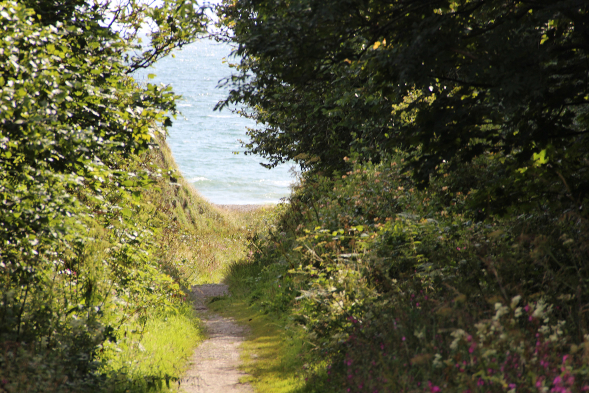
The walk down to St Ninian's Cave is peaceful and gives access to a rough coastal path that leads to the Isle of Whithorn
St Ninian is credited with bringing Christanity to the Pictish people of south west Scotland. You can learn all about him at The Whithorn Story. His shrine is at Whithorn, where he established a church on the site of Whithorn Priory, but local legend says he also inhabited a cave on the coast west of the village as a retreat for solitude and reflection. Christians still visit the site today and mark crosses on the walls. The peaceful walk down to the stony beach and cave from a car park off the A747 (1.5 miles) is through cool, peaceful woodland and contrasts with the windblown cliffs of the coast in the next section of the walk. Once at the steeply sloping beach, where seals sit off and play in the surf, a narrow footpath edges around the headland, in and out of gullies, all the way to the Isle (six miles). This walk is quite arduous so we'd recommend a car at each end, or book a taxi from the Steam Packet Inn, an excellent and rewarding lunch stop.
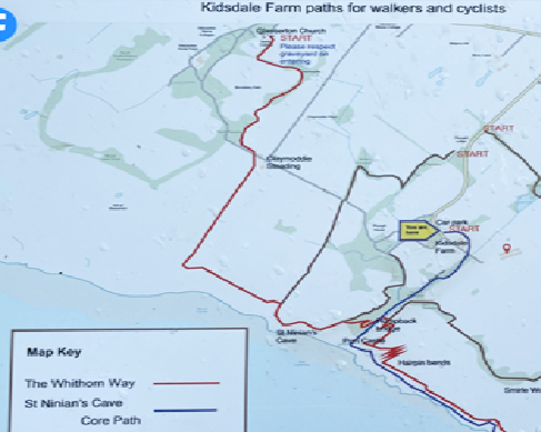
Walking in Galloway: Glasserton Church to St Ninian’s Cave
Glasserton Church to St Ninian’s Cave
The Whithorn Way and Kidsdale Farm paths are excellent. They connect the village of Glasserton to St Ninian’s Cave and on to Burrow Head and the Isle of Whithorn. Many of the paths have been recently upgraded and thread their way through rolling countryside, deciduous woodland and beautiful coastal scenery. Some are now accessible to pedestrians, pushchairs, wheelchairs and bikes. A map with distances is located in the car park at Physgill, where a trail down to St Ninian’s cave begins.
A beautiful walk from the church at Glasserton through rolling countryside and deciduous clumps of woodland, takes you down to the coastline of Luce Bay. Once a favourite spot for smugglers, the path edges around the headland to St Ninian’s Cave, the fabled spot where Scotland’s first saint would retreat from Whithorn for prayer. This walk begins at Glasserton church; a return journey can be made through Physgill woods and via the Claymoddie Steading. Approximately five miles return.
Kirroughtree forest trails

Bruntis Loch, Kirroughtree Forest Park, Galloway is an idyll where Swifts swoop to drink on the wing
Kirroughtree Forest Park offers walks from one to four miles in length following colour-coded waymarkers. They do not bring the challenge of the rough country higher up in the Galloway Hills, but they are delightful and we have enjoyed them many times in all seasons. The woodland is a mix of deciduous trees, natural pines and Forestry Commission plantings. The paths meander through forest and clearings with glimpses of rugged fells and fertile farmland by turns. Red squirrels thrive in these woods and the Commission maintains a special reserve for the animals near the visitors' centre. The landscape is criss-crossed by fierce little streams and lades, man-made channels used in lead mining, which was once a major source of employment in these parts. The water flows from Bruntis Loch, a beautiful, peaceful black lake with a mirror surface on still days. This is a great spot for a picnic.
Walks around Burnside Cottage

The route from Burnside Cottage to Port William is along Garnet's Walk with wonderful views across Luce Bay, Galloway
Burnside Cottage is tucked away in a peaceful valley alongside a very quiet lane. It is surrounded by rolling fields, but just over a ridge behind the property is the sea. A beautiful walk from the back door takes you along a narrow lane, hemmed by hedgerows, before striking off road onto Garnet's Walk, a public footpath, up through the heavy scent of summer gorse and out onto the ridge with views across Luce Bay. From here the trail slopes gently down into Port William, where you can enjoy fish and chips from Tasty Bites eaten on the harbourside or home cooking and a pint at The View restaurant next to the harbour, before walking the 1.5 miles home again.
Alternatively, strain your sinews on the steep hill in front of the cottage, turn right at the top and set out in the direction of Whithorn. After a mile or so, you can enter the estate and gardens of Monreith House, once the home of Gavin Maxwell, author of Ring of Bright Water. The path edges around the White Loch, which sparkles through the trees and bushes that are home to Warblers, Bullfinch and Chiff Chaff as soon as spring arrives. Once you emerge from the estate you can follow the road to Port William and then home again via Garnet's Walk.